 Always worth the visit for some artistic intervention, Hyperallergic directs our attention to a stunning atlas of greed and empire charted out by accomplished gazetteer Dan Mills. His paradoxically brilliant representations of rather bleak facts and figures on the displaced, over-burdened and contested really makes one face the uncomfortable topology that human ambition creates. We found especially poignant this familiar scramble for Antarctica whose claimants’ boundaries radiating out from the South Pole are constantly shifting (see also) not because of politics and sovereignty disputes but purely over melting ice. Much more to explore at the link up top.
Sunday 11 August 2019
orbis terrarum
Saturday 10 August 2019
vous êtes ici
 Sometimes schedules and agendas don’t allow us time to factor in getting lost, wandering a bit and then that blue pulsating dot that seems to get might bossy when you stray off the path or you can’t orientate yourself to that “You are Here” marker on an information board and things get pretty aggravating. Fortunately for those hopeless situations, a major way-finder (one that I’ve come to be rather fond of for foot and auto navigation) has added a augmented reality, live mode to its maps where you can show it your position and the application will use that to determine your exact coordinates and provide landmarks to get you on the right bearings to your destination. Read more at the link above.
Saturday 3 August 2019
crosswalk
 Via Kottke’s Quick Links, we discover Every Noise at Once, an exhaustive scatter-plot map of over thirty-three hundred musical genres jockeyed and charted algorithmically, from a cappella and Blue Grass to Xmasness and Zydeco. Into its sixth year of song taxonomy and curation—surely a potentially fraught and argumentative field, its shifting definitions are data-driven and informed, sampled by meta playlists. There’s no key per se or geographical correlation but south is generally more organic (unplugged) whilst north us mechanical and electric, west is dense and ambient with east being bounicer and spiky.
Sunday 28 July 2019
7x7
gotham: photographer Amey Kandalgaonkar captures Art Deco Shanghai as informed by the dark backgrounds of Batman: The Animated Series—via Nag on the Lake
east-enders: a beautiful collection of photographs from the 1920s—via Strange Company
 my geode must be acknowledged: the brilliant career of Russi Taylor (RIP, *1944 – †2019), actor who voiced Minnie Mouse and Martin Prince—among many, many others
reon pocket: Sony test-markets a wearable air-conditioner
e-plein: Renault may bring back its classic beach buggy as an electric vehicle
pen and ink changes: the British Library has dozens of instructional programmes on how medieval manuscripts were made—via the Art of Darkness
daily planet: visualising how a constellation of satellites work together to create a diurnal snapshot of the Earth—previously
Sunday 14 July 2019
endonymy
From one of our favourite weekly features, Nag on the Lake’s Sunday Links, we are invited to ruminate over the fact that while most countries are named after one of four things—often tautologically, especially in translation—that are sometimes not very consequential to present geopolitics, there are some notable mavericks that defy or really lean into categorisation.
 With nearly all countries named in deference to either a cardinal direction, a distinguishing geographical feature, a tribe or clan or an important personage, we’d wish that the campaign to make America great again was an effort to improve scholarship on the Latinised name of a fifteenth century Florentine cartographer from the Vespucci family but alas and alack. There are nonetheless some notable (and notably disputed too) outliers as well. Our favouites being Malta named for bees (Μελίτη, honey-sweet), Mexico after a simplification of an Aztec city (Mēxihtli) that meant in the navel of the Moon and the Pacific island nation of Nauru, possibly derived from the native conjugation anáoero, I go to the beach.
Saturday 13 July 2019
7x7
fly me to the moons: an interactive atlas of the Solar System’s two hundred known natural satellites—via Maps Mania
favourite things: ten things beloved by US president John Quincy Adams
 canopies: stunning forest photography from Manueli Bececco—see also
placă ceramică: an introduction to the incredible geometries of Romanian socialist era tilework
fine deerscald: a neural network brews up a cuppa—previously
sinistral teichopsia: antique illustrations of aura signatures (scintillating scotoma) that precede the onset of a migraine
republic of minerva: how an utopian micronation and sea-steading caused an international incident in the early 1970s
orrery: four thousand confirmed exoplanets charted in sight and sound
Monday 1 July 2019
pilotage
 The always excellent Nag on the Lake directs our attention to a quite visually captivating coast chart of the world’s lighthouses to include differentiation by their distinctive signal patterns. Lights at Sea not only shows the location of these navigational beacons but also the light class and characteristics, fixed, flashing, coloured or encoded, that help ships triangulate their location upon approaching land.

Saturday 15 June 2019
arterial road
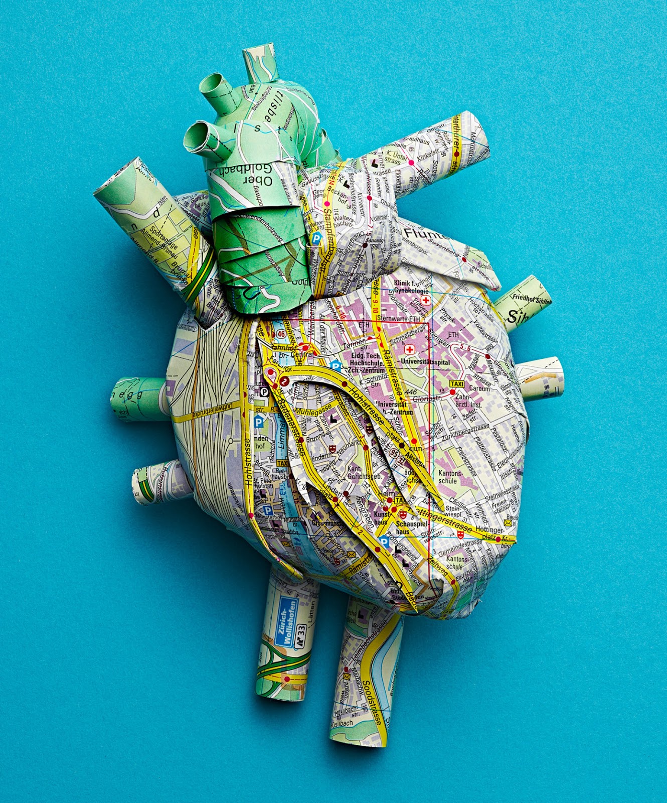 Fusing anatomical studies with paper-sculpting, Berlin-based artist Katrin Rodegast has created several organs fashioned out of maps with roadways and watercourses meant to highlight the similarities of civil engineering (Ein – und Ausfallstraße) with the network of capillaries and arteries in our bodies as a series of commissions for Eidgenössische Technische Hochschule (ETH) Zürich. The Swiss polytechnic’s 2017 chief research thrust was a big collaboration among twenty institutions to make a viable artificial heart—for which Rodegast’s cartographic anatomy was an important part of the outreach programme and partnership cohesion.
Saturday 8 June 2019
culvert journal
 Whether diverted, enlisted as part of the sewer system or simply buried under development, the notion of hidden and lost rivers and urban watercourses has been a particular fascination (previously) and we were especially pleased to come across some speculative spelunking both around London—courtesy of Things Magazine—and Toronto, via Maps Mania. While the London show is more testimony of lives reconstructed through artefact and mudlarking and the Toronto one is an interactive exploration, even connecting to tours that trace the routes of these former tributaries, both are pretty engaging and in both places, the secret, subterranean rivers and creeks have been championed to preserve their memory.
Friday 7 June 2019
7x7
horton plaza: a study of the postmodern ghost mall built to revitalise downtown San Diego
for hire: riotously brilliant hand-painted signs from South Bengal
 big top: Germany’s touring Circus Roncalli replaces animal acts with holograms
cat walk: balloon apparel deflates on the runway and transforms into practical garments
normay: a projection map skewed by the mentions various places get from Donald Trump—via Maps Mania
team breakfast: a fun montage of musicians eating their morning meals, via Everlasting Blört
toward a concrete utopia: a revival in interest for Yugoslavia’s monumental architecture—previously
Thursday 6 June 2019
urban renewal
Never failing to deliver on the interesting and engaging, Coudal Partners’ Fresh Signals refer us to the pioneering Hull House maps of civil and labour rights activist Florence Kelley (*1859 – †1932), whose survey of wages in Chicago neighbourhoods was ground-breaking in terms of data visualisation and making compelling, accessible arguments by this early fusion of sociology and cartography.
 Aside from influencing legislation that led to better working conditions and the eight-hour workday (see also) and living wages, ending child labour and beginning regular inspections of factories to ensure compliance, Kelley was also a founding member of the NAACP and used her considerable sway in the state government to block the passage of discriminatory policies. Learn more about this social justice warrior, her compatriots and predecessors at the links above.
Monday 3 June 2019
6x6
someday my prince will come: life lessons gleaned at the Princess Academy

decolonise this place: a collection of maps presented from an aboriginal perspective, via Nag on the Lake
bathyscope: a ten-hour montage of mesmerising ocean footage
if you just smiled more: an epic discussion thread uses classical paintings to illustrate everyday sexism
the master and margarita: a compelling reading recommendation for Mikhail Bulgakov’s Soviet satire
берёзка: the floating step of a ballet ensemble founded by choreographer Nadezhda Nadezhdina
Thursday 23 May 2019
7x7
bit part: a preview of a biopic about Claude Shannon (previously)—the unsung Father of Information Theory
the revolution will not be biennialised: Banksy (previously) makes an appearance at a Venice expo, selling paintings of giant cruise ships moored in the canals
 en pointe: the Hong Kong Ballet celebrates its fortieth birthday
😾 😾 😾: Thangrycat is exploiting vulnerabilities in the underpinning architecture of the internet
urban spelunking: when the Jehovah’s Witnesses relocated from Brooklyn Heights to upstate, their vacated properties included a series of underground passageways, via Super Punch
conducive to learning: a collection of striking maps and charts that inspired pupils in the late nineteenth century
walking trot: phones can now determine who is carrying them by knowing their users’ gait and other kinematic factors, via Slashdot
Sunday 19 May 2019
vie et habitat des animaux fantastique
 Via the always amazing Maps Mania, we are directed towards an incredible interactive version of Jean-Baptiste-Louis Franquelin “Carte Genlle. de la France Septle. Contenant la Descouverte du Pays des Illinois” (1675) mapping an expedition two years earlier down the Mississippi River geographically as well as noting the mostly real though sometimes purely fantastical beasts and at other times challenged for the right habit in a comprehensive chart and travelogue for the governor of New France.
 Be sure to check out the source link up top for more original and historical maps in the same vein and other more contemporary examples of limning in terra nullius and terra incognito as points unknown with comparable esoteric warnings (hic sunt dracones and other related cautionary signs).
Wednesday 8 May 2019
7x7
electronium: a classic electronic music sequencer from pioneer Raymond Scott is reinvented with an artificial intelligence software patch
sacred spaces: Thibaud Poirier photographs modern church interiors
 the right to be forgotten: internet giant allows users to control if and for how long it retains one’s data
spoorzone: a self-sustaining bus station in Tilburg
b(7)b: a handy guide to the re-categorised information withholds of the latest version of the Mueller Report released to the public
h. p. loveshack: ph’nglui mglw’nafh Cthulhu R’lyeh wgah’nagl fhtagn
hic sunt dracones: an interactive map of legends from English Heritage—via Maps Mania
Friday 3 May 2019
8x8
shuudan koudou: the Japanese art of synchronised, precision walking
how happy we could be if we’d only listen to our kitschy teacups: cheerfulness is not a virtue and rather an equal opportunity vice
 shortlisted: a curated selection of submissions to National Geographic’s travel photography competition
the wookie roars: RIP Peter Mayhew (*1944 – †2019)
tiger on tour: during the height of the Space Race, Esso gave away maps of the Moon
deplatformed: garbage social media ejected a bunch of garbage provocateurs, though the stunt is more publicity for the banned
klimaanlage: researchers in Karlsruhe study enlisting air conditioning units to pull carbon dioxide out of the air
yijin jing: watching Shaolin Kung Fu training from above (previously)
Friday 26 April 2019
7x7
imperium: the rise and fall of colonial powers visualised
aggressively, chillingly ahuman: for some inscrutable algorithmic purpose, a bot created a video of a blog post—via Super Punch
 wholecloth: these colourful quilts from artist Bisa Butler that tell a story
acanthus leaf: Plants and their Application to Ornament (1896) from Eugène Grasset
totus mundus agit histrionem: for the Bard’s birthday, a Shakespearean version of Trivial Pursuit
law-suuuuuuuu-uuuit: the yodeller behind the Yahoo! campaign was led to believe it was only a regional promotion—via Miss Cellania’s Links
belt and road project: the Australian Strategic Policy Institute conducted a comprehensive study of Chinese technological influence globally—via Maps Mania
Friday 19 April 2019
urban legend
 Our intrepid explorers at Atlas Obscura lead us to a deliriously crowded, Mid-Century Modern style annotated map of New York City, drafted in the early 1950s by Nils Hansell. Filled with local-lore, infamy and tall tales that we cannot necessarily vouch for, “The Wonders of New York” features over three hundred exclusive haunts and happenings of yesteryear to consider, the landscape having transformed considerably despite the layout basically remaining true-to-form.
 Visit the link above to zoom in greater detail and discover what’s changed about the character of each neighbourhood. Rogues’ galleries and hyperbole aside, I wonder if in the not so distant future, people will find equally preposterous that a certain quarter had flea circuses, livestock and stevedores.
Thursday 4 April 2019
clang, clang, clang went the trolley
 Via the always engrossing Things Magazine, we are treated to a very nicely curated interactive gallery of the charts and strip maps of artist Jake Berman (previously) that allows one to compare historic public transportation systems (see also) with their modern equivalents for several US cities.
 Reaching back more than a century in some cases, Berman plots old train and street car routes—or ambitious proposals pared back versus their contemporary circuits and study in detail how coverage has expanded or contracted.
Sunday 31 March 2019
polar azimuthal projection
Via Strange Company, we are introduced to the magnificent, late sixteenth century chart of the known world, Urbano Monte’s Planisphere.
 Splitting from the traditional representation of the globe made the industry-standard by Flemish mapmaker Gerardus Mercator in the preceding century, which portrayed the constant bearings of sailing vessels (curved rhumb lines) as straight paths, Monte deconstructed the round Earth as sixty separate surfaces that could be reassembled to study the entire atlas comprehensively. The resulting masterwork is full of tiny details and illustrations but is also testament to Monte’s geographic understanding on a continent scale, surpassing his peers by getting the Mediterranean and Africa more to scale than other depictions and not making California an island. More to explore at the links above.


